


오늘 산행하는 하룻동안 흐린 날씨, 비, 우박, 진눈깨비, 싸락눈, 눈, 맑은 하늘을 모두 만났다.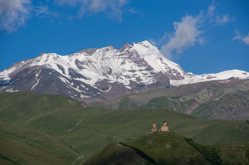


Mount Kazbek
| Mount Kazbek | |
|---|---|
 Mount Kazbek | |
| Elevation | 5,033 m (16,512 ft) |
| Prominence | 2,353 m (7,720 ft) |
| Listing | Ultra |
| Location | |
| Location | |
| Range | Caucasus |
| Coordinates | |
| Geology | |
| Type | Stratovolcano (dormant) |
| Last eruption | approx. 750 BC |
| Climbing | |
| First ascent | 1868 by Douglas Freshfield, A. W. Moore and C. C. Tucker |
| Easiest route | basic snow/ice climb |
Mount Kazbek (Georgian: ყაზბეგი (or მყინვარწვერი), Ossetic: Сæна, Russian: Казбек, Chechen: Башлам), is a dormant stratovolcano and one of the major mountains of the Caucasus located on the border of Kazbegi District of Georgia and North Ossetia.[3] It is the third highest mountain in Georgia (after Mount Shkhara and Janga) and the seventh highest peak in the Caucasus Mountains. The summit lies directly to the west of the town of Stepantsminda and is the most prominent geographic feature of the area. The name in Georgian, Mkinvartsveri, translates to "glacier" or "Ice Mountain". The Vainakh name Bashlam translated as Molten Mount.
Contents[hide] |
[edit] Location
Kazbek is located on the Khokh Range, a mountain range which runs north of the Greater Caucasus Range, and which is pierced by the gorges of the Ardon and the Terek. The mountain itself lies along the edge of the Borjomi-Kazbegi Fault (which is a northern sub-ending of the Anatolian Fault). The region is highly active tectonically, with numerous small earthquakes occurring at regular intervals. An active geothermal/hot spring system also surrounds the mountain. Kazbek is a potentially active volcano, built up of trachyte and sheathed with lava, and has the shape of a double cone, whose base lies at an altitude of 1,770 meters (5,800 feet). Kazbek is the highest of the volcanic cones of the Kazbegi volcanic group which also includes Mount Khabarjina (3142 metres).
Owing to the steepness of its slopes, the glaciers of Kazbek are not very large. The total combined area of all of Kazbek's glaciers is 135 km². The best-known glacier is the Dyevdorak (Devdaraki), which creeps down the north-eastern slope into a gorge of the same name, reaching a level of 2,295 meters (7,530 feet). Kazbek's other glaciers include the Mna, Denkara, Gergeti, Abano and Chata. The recent collapse of the Kolka Glacier, located in a valley between Mt. Jimara and Kazbek in the year 2002 was attributed to solfatara volcanic activity along the northern slope of the mountain, although there was no eruption. At its eastern foot runs the Georgian Military Road through the pass of Darial 2,378 meters (7805 feet).
[edit] Legend

Mount Kazbek is associated in Georgian folklore with Amirani, the Georgian version of Prometheus, who was chained on the mountain in punishment for having stolen fire from the gods and having given it to mortals. The location of his imprisonment later became the site of an Orthodox hermitage located in a cave called “Betlemi” (Bethlehem) at around the 4000 meter level. According to legends, this cave housed many sacred relics, including Abraham's tent and the manger of the infant Jesus.[4]

The summit was first climbed in 1868 by D. W. Freshfield, A. W. Moore, and C. Tucker of the London Alpine Club, with a Swiss guide. They were followed by the female Russian alpinist Maria Preobrazhenskaya, who made the climb nine times starting in the year 1900.
[edit] Kazbegi Nature Reserve
The area around Mount Kazbegi was designated a nature reserve by the Soviet government in 1979, and includes beech forests, subalpine forests and alpine meadows. Many of the plants and animals in the reserve are endemic to the Caucaus region.
Caucasus Mountains
| Caucasus Mountains | |
| Range | |
 Khinalug settlement in Azerbaijan has a history of 5,000 years | |
| Countries | Russia, Georgia, Azerbaijan, Armenia, Iran, Turkey |
|---|---|
| Highest point | Mount Elbrus |
| - elevation | 5,642 m (18,510 ft) |
| - coordinates | |
| Length | 1,100 km (684 mi) |
| Width | 160 km (99 mi) |
 Satellite image | |
The Caucasus Mountains is a mountain system in Eurasia between the Black Sea and the Caspian Sea in the Caucasus region (Azerbaijani: Qafqaz Armenian: Կովկասյան լեռներ Georgian: კავკასიონი Russian: Кавказские горы).
The Caucasus Mountains includes:
- the Greater Caucasus Mountain Range and
- the Lesser Caucasus Mountains.
The Greater Caucasus Range extends from the Caucasian Natural Reserve in the vicinity of Sochi on the northeastern shore of the Black Sea, generally trending east-southeast and reaching nearly to Baku on the Caspian Sea, while the Lesser Caucasus runs parallel to the greater range, at a distance averaging about 100 km (62 mi) south. The Meskheti Range is a part of the Lesser Caucasus system. The Greater and Lesser Caucasus ranges are connected by the Likhi Range, which separates the Kolkhida Lowland from the Kura-Aras Lowland. In the southeast are the Talysh Mountains. The Lesser Caucasus and the Armenian Highland constitute the Transcaucasian Highland. The highest peak in the Caucasus range is Mount Elbrus in the Greater Caucasus, which rises to a height of 5,642 metres (18,510 ft) above sea level. Mountains near Sochi will host part of the 2014 Winter Olympics.
Contents[hide] |
[edit] Geology
The Caucasus Mountains formed largely as the result of a tectonic plate collision between the Arabian plate moving northward with respect to the Eurasian platecitation needed. The entire region is regularly subjected to strong earthquakes from this activity. The Lesser Caucasus Mountains on the other hand, is largely of volcanic origin. The Javakheti Volcanic Plateau in Georgia and the surrounding volcanic ranges which extend well into central Armenia are some of the youngest features of the region.
There are large hydrocarbon reserves in the area especially near the Caspian Sea.
[edit] Geographical affiliation
There is no clear agreement on whether the Caucasus Mountains are a part of Europe or Asia. Thus Europe's highest mountain is either Mount Elbrus 5,642 m (18,510 ft), in the Caucasus Mountains, or Mont Blanc 4,810 m (15,781 ft), in the Alps at the Italian-French border, depending on which continent the Caucasus Mountains are assigned to.
The Caucasus Mountains are located in the middle of the Eurasian plate between Europe and Asia. The ancient Greeks saw the Turkish Straits and the Caucasus Mountains as the border of Europe, while it has to be considered that Caucasus also referred to the Caucasus Indicus (modern day Hindu Kush). Later this concept changed several times for political reasons. In the Migration Period and the Middle Ages, the Turkish Straits and the river Don divided the two continents.
The border was defined by the Swedish military officer and geographer Philip Johan von Strahlenberg, who suggested the border follow the peaks of the Urals, and then the lower Emba and the coast of the Caspian Sea, before passing through the Kuma-Manych Depression, which lies 300 km (186.41 mi) north of the Caucasus Mountains. In 1730, this course was approved by the Russian Tsar and since then was adopted by many scientists. Following this definition, the mountains are a part of Asia and according to this view, the highest Mont Blanc.
On the other hand, La Grande Encyclopédie clearly draws the border between Europe and Asia south of both Caucasian mountain ranges.[citation needed] Both Elbrus and Kazbek are European mountains by this definition. While clearly not a scientific definition, most mountain climbers consider Mt. Elbrus to be the highest mountain in Europe.[1][2]
[edit] Notable peaks
The table below lists some of the highest peaks of the Caucasus. With the exception of Shkhara, the heights are taken from Soviet 1:50,000 mapping. There are higher and more prominent, but nameless, peaks than some of the peaks included below.

| Peak Name | Elevation (m) | Prominence (m) | Country |
|---|---|---|---|
| Elbrus | 5,641 | 4,741 | Russia |
| Dykh-Tau | 5,205 | 2,002 | Russia |
| Shkhara | 5,201 | 1,365 | Georgia |
| Koshtan-Tau | 5,152 | 822 | Russia |
| Janga (Jangi-Tau) | 5,059 | 300 | Georgia |
| Kazbek | 5,047 | 2,353 | Georgia |
| Pushkin | 5,033 | 110 | Russia/Georgia |
| Katyn-Tau | 4,979 | 240 | Russia/Georgia |
| Shota Rustaveli | 4,860 | c.50 | Georgia |
| Tetnuldi | 4,858 | 672 | Georgia |
| Mount Bazardüzü | 4,466 | Azerbaijan | |
| Mount Shahdagh | 4,243 | Azerbaijan |
See also: List of the most prominent mountains in the Caucasus
[edit] Climate

The climate of the Caucasus varies both vertically (according to elevation) and horizontally (by latitude and location). Temperature generally decreases as elevation rises. Average annual temperature in Sukhumi, Abkhazia at sea level is 15 degrees Celsius while on the slopes of Mt. Kazbek at an elevation of 3700 metres, average annual temperature falls to -6.1 degrees Celsius. The northern slopes of the Greater Caucasus Mountain Range are 3 degrees (Celsius) colder than the southern slopes. The highlands of the Lesser Caucasus Mountains in Armenia, Azerbaijan, and Georgia are marked by sharp temperature contrasts between the summer and winter months due to a more continental climate.

Precipitation increases from east to west in most areas. Elevation plays an important role in the Caucasus and mountains generally receive higher amounts of precipitation than low-lying areas. The northeastern regions (Dagestan) and the southern portions of the Lesser Caucasus Mountains are the driest. The absolute minimum annual precipitation is 250 mm (9.84 in) in the northeastern Caspian Depression. Western parts of the Caucasus Mountains are marked by high amounts of precipitation. The southern slopes of the Greater Caucasus Mountain Range receive higher amounts of precipitation than the northern slopes. Annual precipitation in the Western Caucasus ranges from 1,000–4,000 mm (39.37–157.48 in) while in the Eastern and Northern Caucasus (Chechnya, Ingushetia, Kabardino-Balkaria, Ossetia, Kakheti, Kartli, etc.) precipitation ranges from 600–1,800 mm (23.62–70.87 in). The absolute maximum annual precipitation is 4,100 mm (161.42 in) around the Mt. Mtirala area which lies on the Meskheti Range in Ajaria. The precipitation of the Lesser Caucasus Mountain Range (Southern Georgia, Armenia, western Azerbaijan), not including the Meskheti Range, varies from 300-800 mm (31.50 in) annually.

The Caucasus Mountains are known for the high amount of snowfall, although many regions which are not located along the windward slopes do not receive nearly as much snow. This is especially true for the Lesser Caucasus Mountains which are somewhat isolated from the moist influences coming in from the Black Sea and receive considerably less precipitation (in the form of snow) than the Greater Caucasus Mountains. The average winter snow cover of the Lesser Caucasus Mountains ranges from 10–30 cm (3.94–11.81 in). The Greater Caucasus Mountains (especially the southwestern slopes) are marked by heavy snowfall. Avalanches which are common from November-April.
Snow cover in several regions (Svanetia, northern Abkhazia ) may reach 5 metres (16 ft). The Mt. Achishkho region, which is the snowiest place in the Caucasus, often records snow depths of 7 m (23 ft).
[edit] Landscape
.jpg)
The Caucasus Mountains have a varied landscape which mainly changes vertically and according to the distance from large bodies of water. The region contains biomes ranging from subtropical low-land marshes/forests to glaciers (Western and Central Caucasus) as well as highland semideserts/steppes and alpine meadows in the south (mainly Armenia and Azerbaijan).
The northern slopes of the Greater Caucasus Mountains are covered by oak, hornbeam, maple, and ash forests at lower elevations while birch and pine forests take over at higher elevations. Some of the lowest locations/slopes of the region are covered by steppes and grasslands. The slopes of the Northwestern Greater Caucasus (Kabardino-Balkaria, Cherkessia, etc.) also contain spruce and fir forests. The alpine zone replaces the forest around 2,000 metres above sea level. The permafrost/glacier line generally starts around 2,800-3,000 metres. The south-eastern slopes of the Greater Caucasus Mountains are covered by beech, oak, maple, hornbeam, and ash forests. Beech forests tend to dominate in higher locations. The south-western slopes of the Greater Caucasus are covered by Colchian forests (oak, buxus, beech, chestnut, hornbeam, elm) at lower elevations with coniferous and mixed forests (spruce, fir and beech) taking over at higher elevations. The alpine zone on the southern slopes may extend up to 2,800 metres above sea level while the glacier/snow line starts from 3,000-3,500 metres.

The northern and western slopes of the Lesser Caucasus Mountains are characterized both by Colchian and other deciduous forests at lower elevations while mixed and coniferous forests (mainly spruce and fir) dominate at higher elevations. Beech forests are also common at higher elevations. The southern slopes of the Lesser Caucasus Mountains are largely covered by grasslands and steppes up to an elevation of 2,500 metres. The highest areas of the region contain alpine grasslands as well. Volcanic and other rock formations are common throughout the region. The volcanic zone extends over a large area from southern Georgia into Armenia and southwestern Azerbaijan. Some of the prominent peaks of the region include Mt. Aragats, Didi Abuli, Samsari, and others. The area is characterized by volcanic plateaus, lava flows, volcanic lakes, volcanic cones and other features. The Lesser Caucasus Mountains lack the type of glaciers/glacial features that are common on the Greater Caucasus Mountain Range.