


Source: http://www.theatlantic.com/photo/2016/03/images-from-offworld/476061/
Images From Offworld
Mar 30, 2016
31 Photos
In Focus
Robotic probes launched by NASA, the European Space Agency (ESA),
and others are gathering information all across the solar system.
We currently have spacecraft in orbit around the Sun, Venus, Earth, Mars, Ceres, a comet, and Saturn;
two operational rovers on Mars; and a recent close flyby of Pluto and its moons.
Astronauts aboard the International Space Station are still performing experiments in low Earth orbit and sending back amazing photos.
With all these eyes in the sky,
I’d once again like to put together a recent photo album of our solar system—a set of family portraits—
as seen by our astronauts and mechanical emissaries.
This time, we have our closest look yet at the bright spots on the dwarf planet Ceres,
the shadow of an eclipse on Earth seen from a million miles away,
a variety of landscapes on Mars,
wonderful images of Saturn and its moons,
several images from Pluto, and,
of course, lovely images of our home, planet Earth.
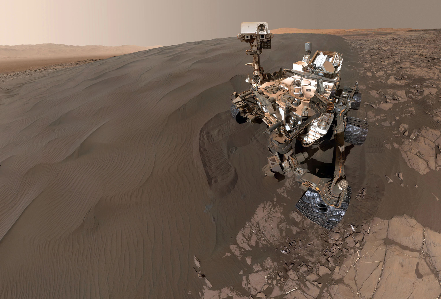
This self-portrait of NASA's Curiosity Mars rover shows the vehicle at “Namib Dune,” where the rover's activities included scuffing into the dune with a wheel and scooping samples of sand for laboratory analysis. The scene combines 57 images taken on January 19, 2016, during the 1,228th Martian day, or sol, of Curiosity's work on Mars. The camera used for this is the Mars Hand Lens Imager (MAHLI) at the end of the rover's robotic arm. Namib Dune is part of the dark-sand “Bagnold Dune Field” along the northwestern flank of Mount Sharp. Images taken from orbit have shown that dunes in the Bagnold field move as much as about 3 feet (1 meter) per Earth year. #

The sun, imaged by the Atmospheric Imaging Assembly instrument aboard NASA's Solar Dynamics Observatory, on November 12, 2015. #
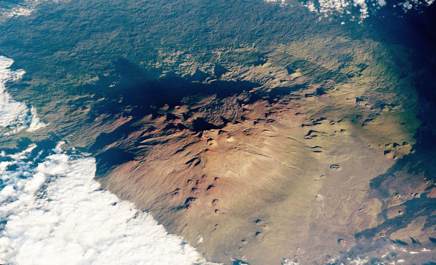
Mauna Kea, or White Mountain, is the only volcano on the island of Hawaii that has evidence of glaciation. This photograph of Mauna Kea was taken by an astronaut as the International Space Station passed over at approximately 5 p.m. local time on November 1, 2015. The late-afternoon lighting and oblique viewing angle accentuates the shadows, highlighting the white domes of the observatories along the crater rims. The angle also accentuates the numerous cinder cones and lava flows. #

The Moon seen from orbit aboard the ISS on March 25, 2016, above New Zealand. #

Much of London and its suburbs are visible in this photograph taken from the International Space Station on September 27, 2015. #
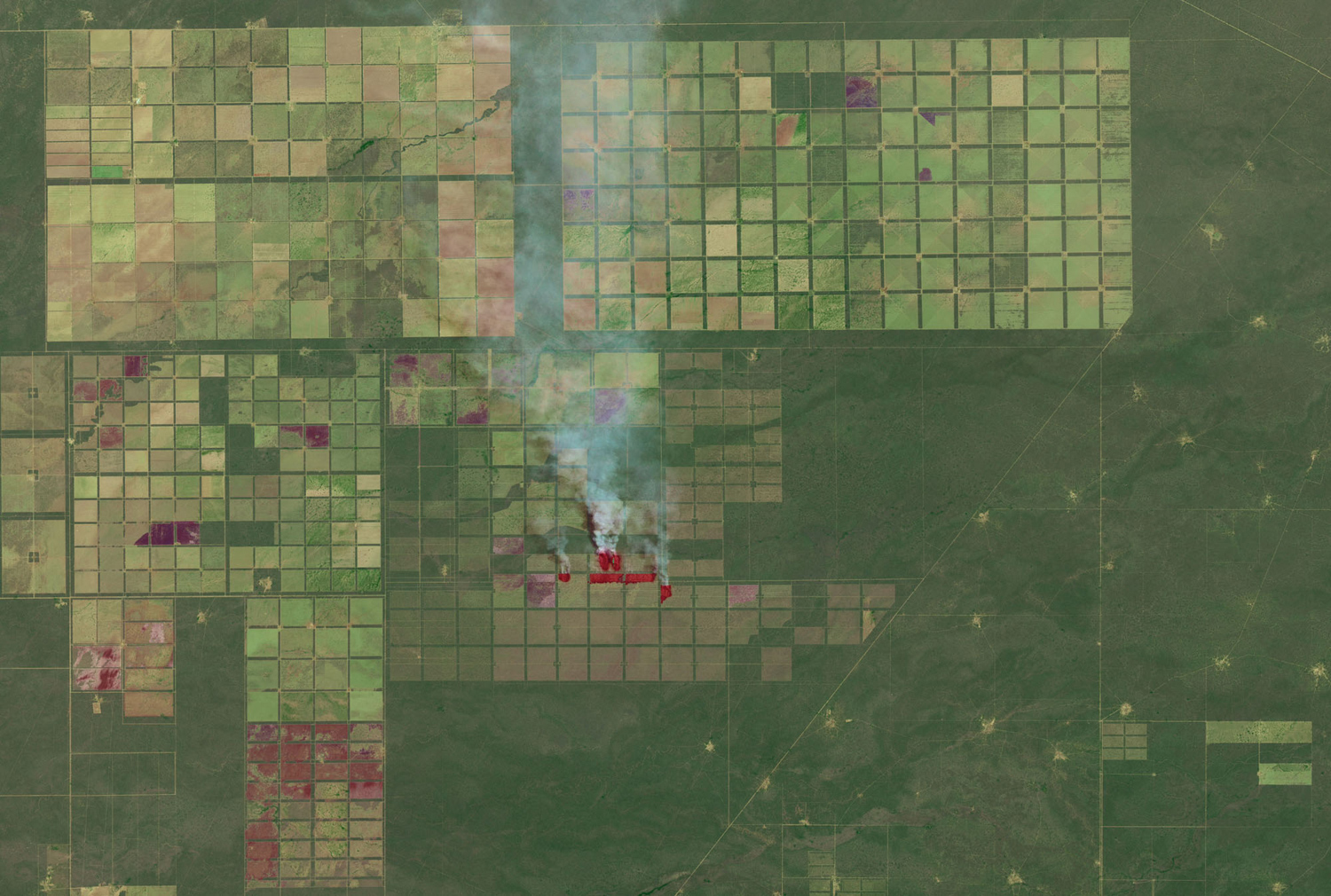
The chaco forests of northern Argentina spread across a vast outwash plain in the center of South America. Shrubs and hardwood forests thrive in the semi-arid region. For many years, puestos—small settlements centered around water sources—dotted the landscape. But in the past decade, large-scale farm and ranch operators have cleared broad swaths of the chaco to make way for livestock and crops raised on an industrial scale. In fact, an analysis of data collected by several Landsat satellites suggests that Argentina’s chaco faces one of the fastest tropical deforestation rates in the world. On October 15, 2015, the Operational Land Imager (OLI) on Landsat 8 captured this false-color image of fields, forests, and puestos in the Salta province of northern Argentina. Fires are actively burning in a few sectors of the grid, likely lit by land managers trying to clear shrubs and trees to make room for livestock, timber, or crops. Fresh burn scars are dark brown; older burn scars are lighter brown. Over time, burned areas become light green and eventually dark green. #
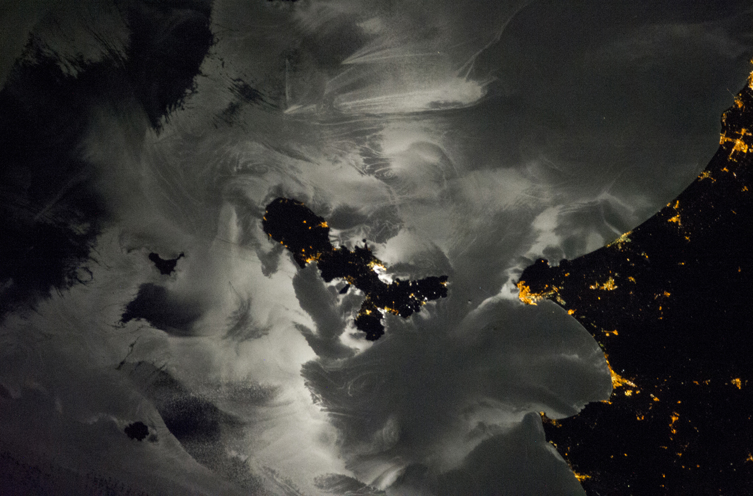
A crew member aboard the International Space Station took this photograph of the northern Mediterranean Sea and some coastal Italian towns and islands. The reflection of the moon on the sea surface reveals highly complex patterns. The strongest reflection is near the center of the moon’s disc, which brightens the water around the island of Elba. In these complex patterns, the dark areas of the sea surface can sometimes make islands (such as Montecristo and Pianosa) harder to see. The reflection off sea surfaces captures many different natural processes, but also some made by humans. North of Elba, waves trailing behind ships make the classic V-shaped pattern. The meandering line coming off Montecristo Island is an “island wake,” a result of alternating vortices of wind that develop on the downwind side of the island. This wake is the strongest evidence that a northeast wind was blowing (right to left in this image) on the night of the photo. A shorter, meandering wind pattern is being shed off Punta Ala on the mainland. #
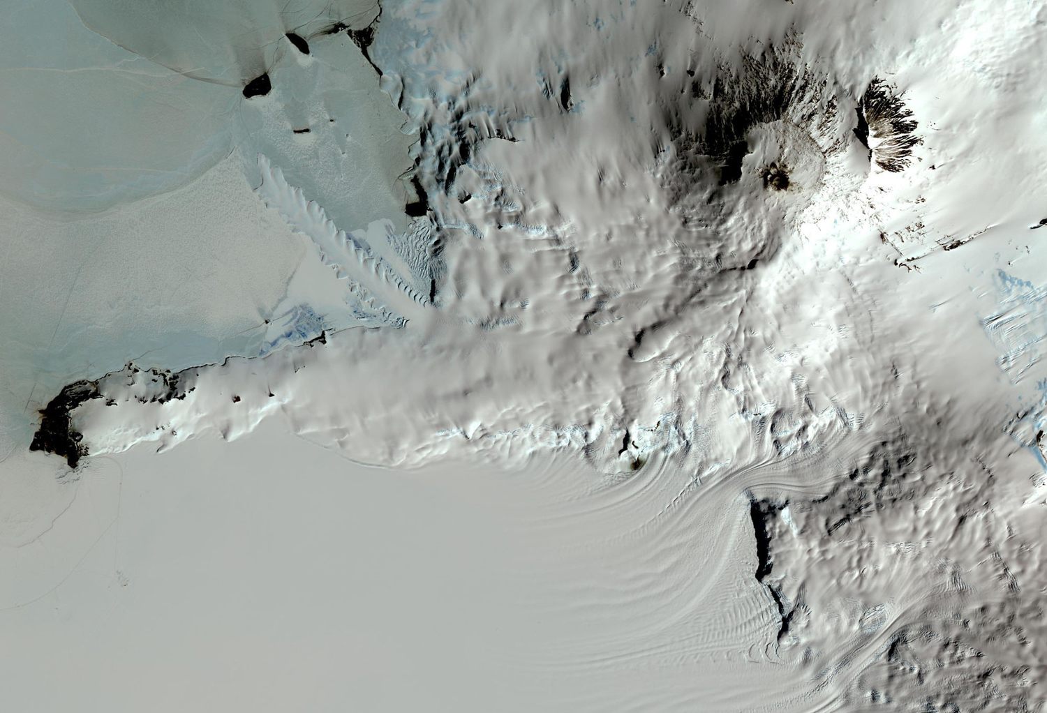
Seen by ASTER, an imaging instrument onboard Terra, one of NASA's Earth Observing System satellites, Mount Erebus, the world's southernmost historically active volcano, overlooks the McMurdo research station on Ross Island, Antarctica. The 3794-meter-high Erebus is the largest of three major volcanoes forming the crudely triangular Ross Island. Continuous lava-lake activity with minor explosions, punctuated by occasional larger strombolian explosions that eject bombs onto the crater rim, has been documented since 1972, but has probably been occurring for much of the volcano's recent history. Image taken on December 31, 2013, released on January 15, 2016. #

Aboard the ISS, off North America's east coast, on March 27, 2016. #
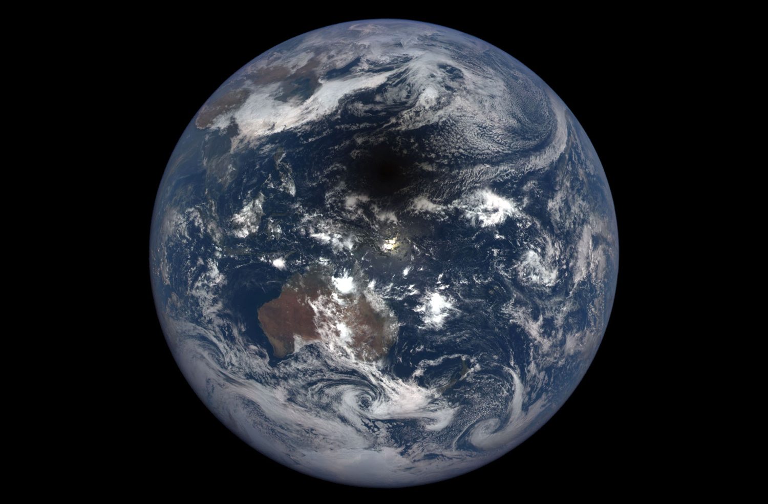
NASA's EPIC camera, aboard NOAA's DSCOVR satellite, captured a unique view of a solar eclipse on March 9, 2016. While residents of the Western Pacific looked up in the early morning hours to observe a total eclipse of the sun, DSCOVR looked on from a million miles away and captured the shadow of the moon crossing the planet, seen here just above the sun’s reflection in the Pacific Ocean. A million miles away, NOAA's DSCOVR satellite is the Nation's first operational satellite in deep space. DSCOVR hovers between the sun and Earth at all times, maintaining a constant view of the sun and sun-lit side of Earth. #
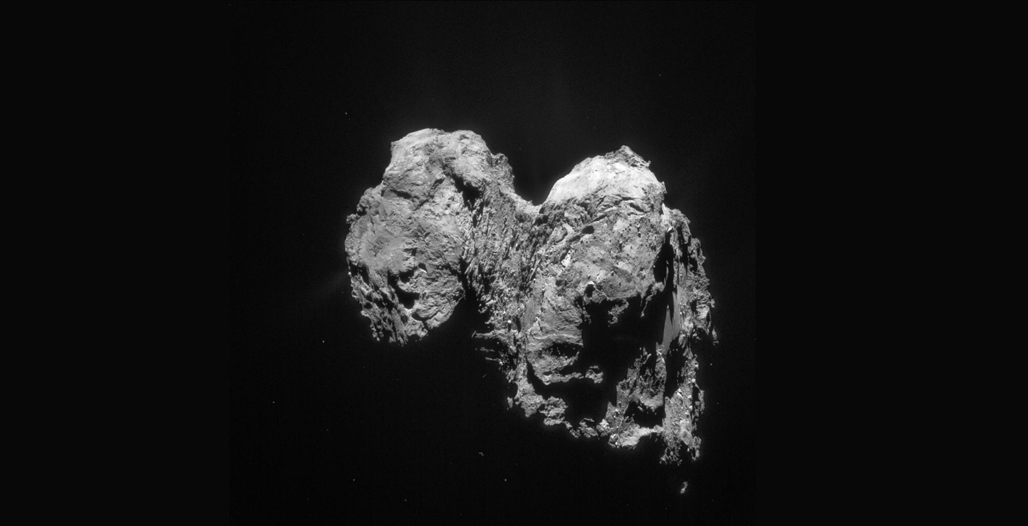
This single frame Rosetta navigation camera image of Comet 67P/Churyumov-Gerasimenko was taken on September 11, 2015, from a distance of 319 kilometers from the comet center. The image has a resolution of 27.2 m/pixel and measures 27.9 kilometers across. #
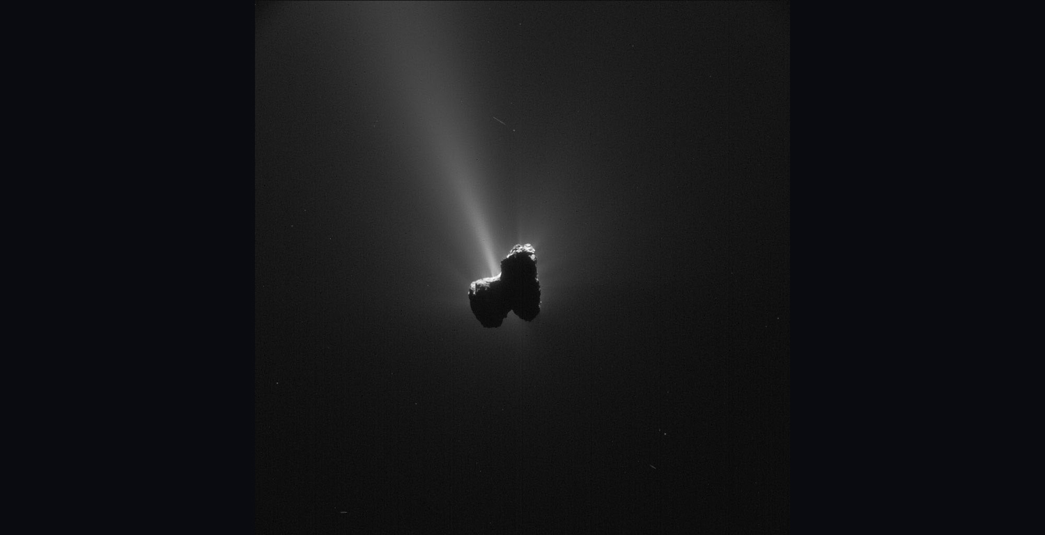
Single frame NavCam image taken on January 28, 2016, when Rosetta was 67.6 kilometers from the nucleus of Comet 67P/Churyumov-Gerasimenko. #
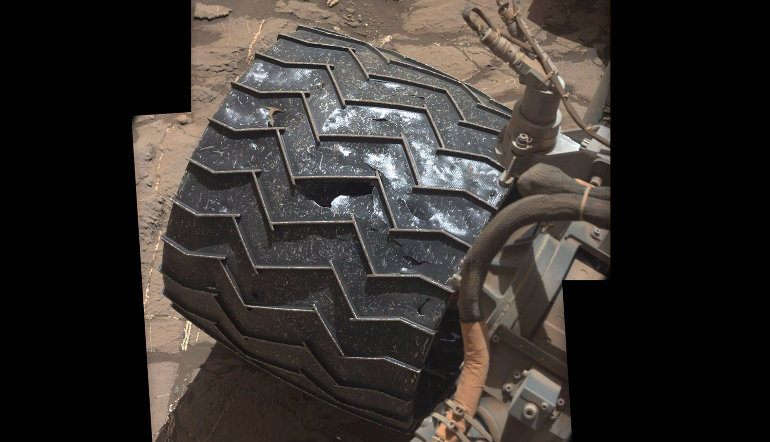
Some of the minor damage to one of Curiosity‘s wheels, after more than 1,300 days rolling across the surface of Mars. NASA team members have been monitoring dents and tears in the aluminum skin of the wheels for several years now, but appear to be reassured that the treads remain relatively undamaged. Photo taken on November 30, 2015. #

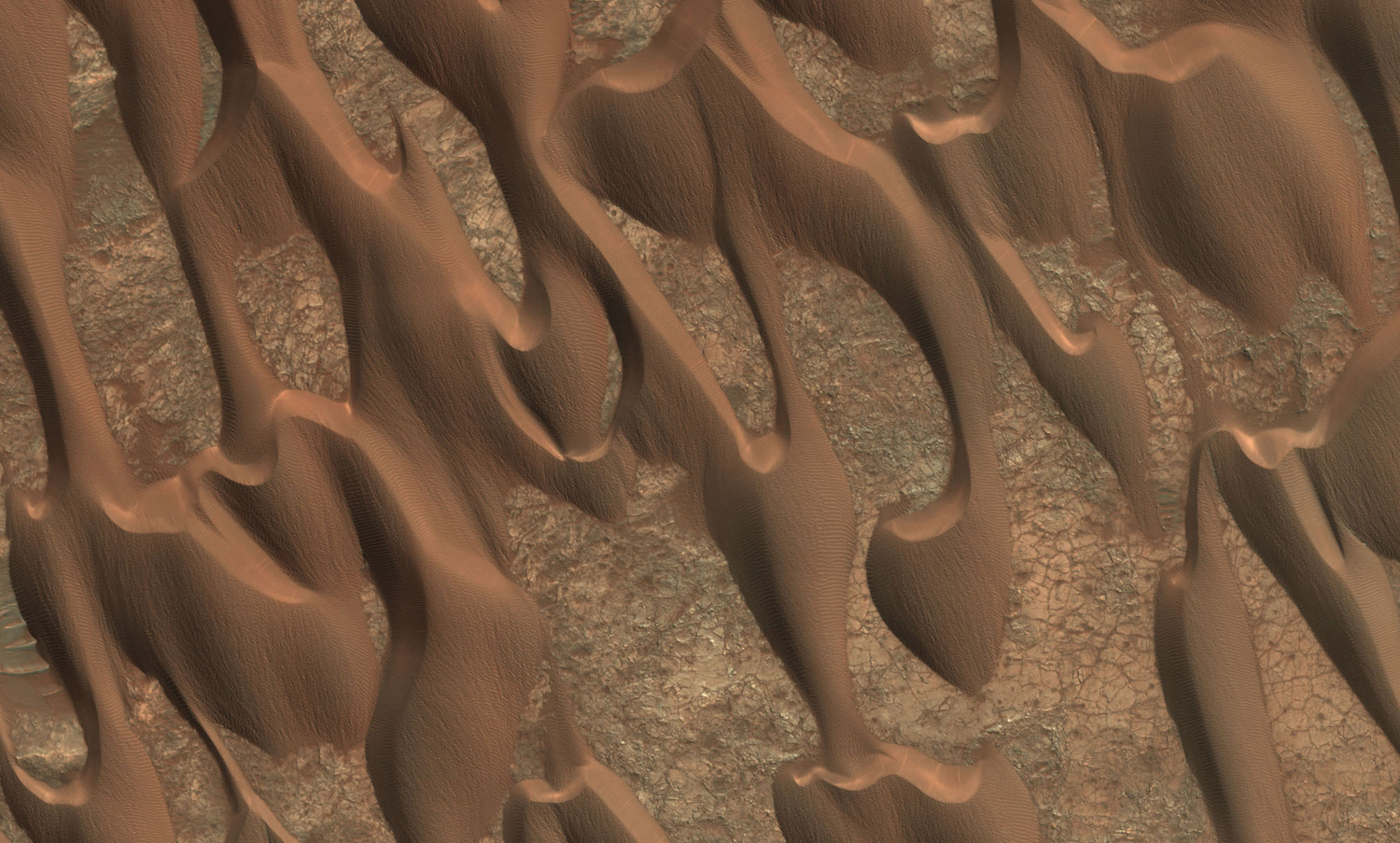
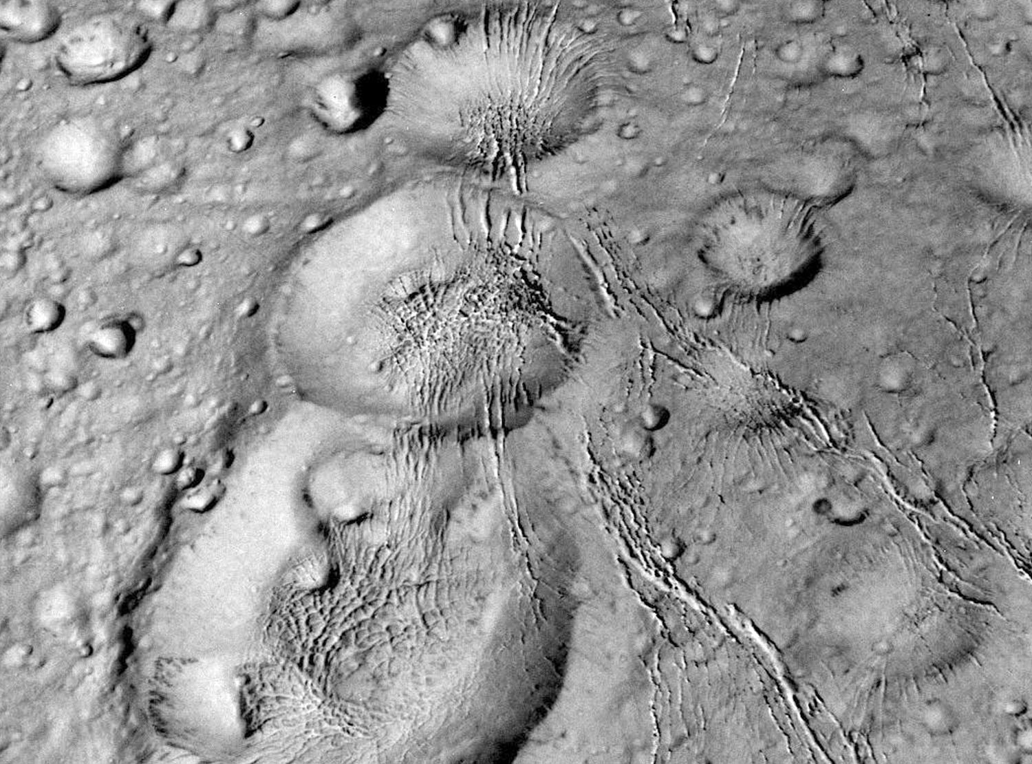
Delicate features on the surface of Mars, on sol 1283, March 16, 2016. #
On Mars, dark butte-capping material in a mid-latitude crater floor, imaged by the HiRISE instrument aboard NASA's Mars Reconnaissance Orbiter, on December 25, 2015. #
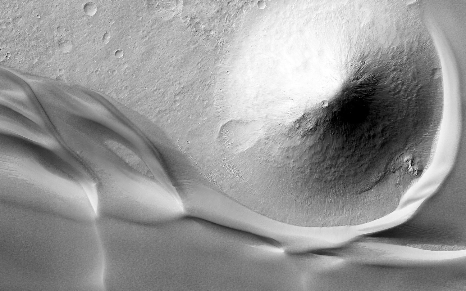
On Mars, the eastern edge of a very large deposit of wind-blown dust that occupies Ganges Chasma, imaged by the HiRISE instrument aboard NASA's Mars Reconnaissance Orbiter, March 10, 2016. #
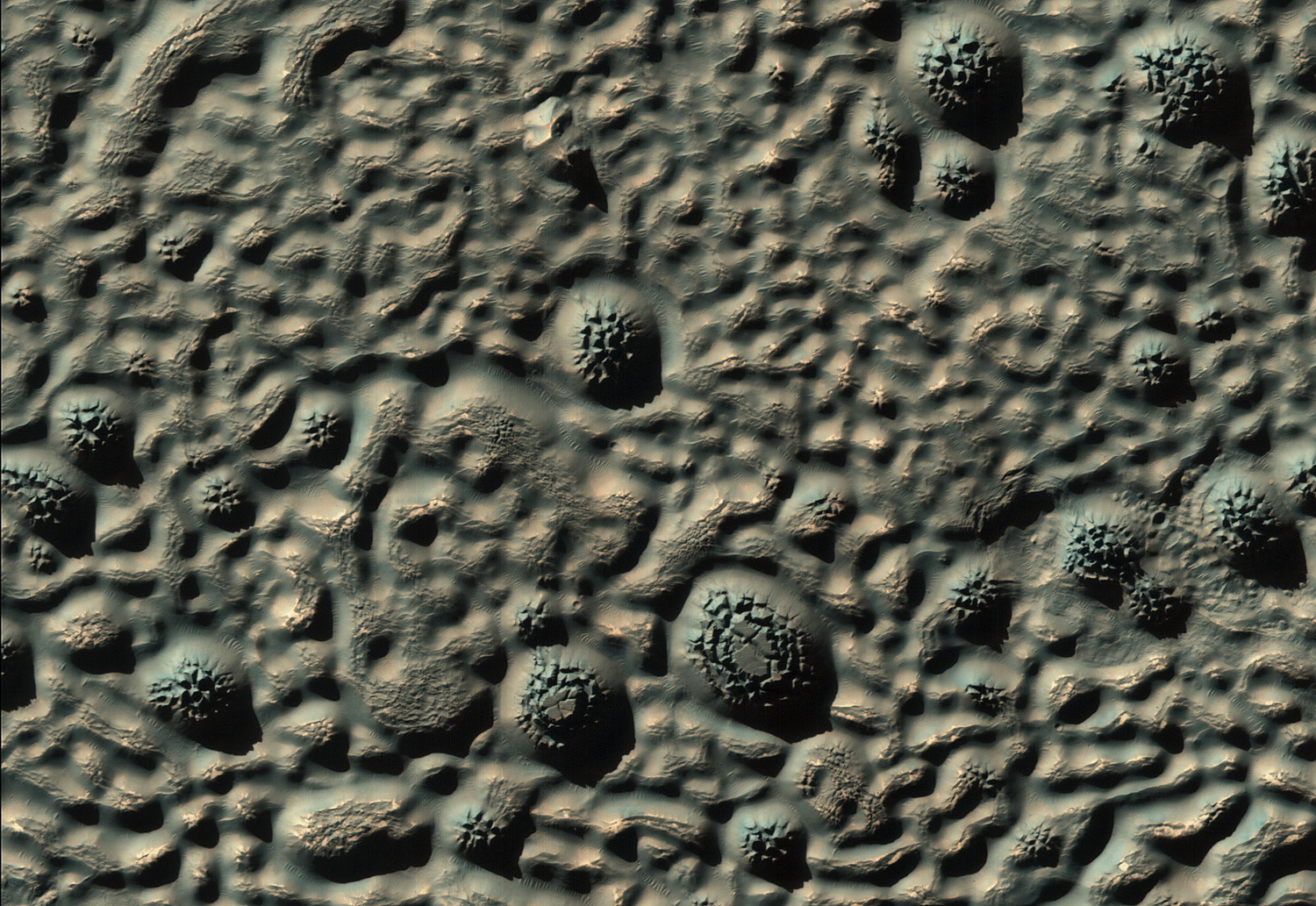
The dunes of Nili Patera, imaged by the HiRISE instrument aboard NASA's Mars Reconnaissance Orbiter, December 31, 2015. #

The Mars Hand Lens Imager (MAHLI) camera on the robotic arm of NASA's Curiosity Mars rover used electric lights at night to illuminate this close-up view of Martian sand grains dumped on the ground after sorting with a sieve. The view covers an area roughly 1.1 inches by 0.8 inch (2.8 centimeters by 2.1 centimeters). The grains seen here were too large to pass through a sieve with 150-micron (0.006 inch) pores. They were part of the sand in the first scoop collected by Curiosity at “Namib Dune.” The images combined into this focus-merged view were taken on January 22, 2016, after dark on the 1,230th Martian day, or sol, of Curiosity's work on Mars. The illumination source is two white-light LEDs on MAHLI. #

This composite image looking toward the higher regions of Mount Sharp was taken on September 9, 2015, by NASA's Curiosity rover. In the foreground—about 2 miles (3 kilometers) from the rover—is a long ridge teeming with hematite, an iron oxide. Just beyond is an undulating plain rich in clay minerals. And just beyond that are a multitude of rounded buttes, all high in sulfate minerals. The changing mineralogy in these layers of Mount Sharp suggests a changing environment in early Mars, though all involve exposure to water billions of years ago. #
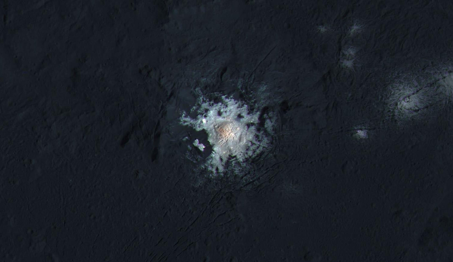
The bright central spots near the center of Occator Crater are shown in enhanced color in this view from NASA's Dawn spacecraft. The exact nature of the bright material is still not known. Ralf Jaumann, planetary scientist and Dawn co-investigator at the German Aerospace Center in Berlin said “the intricate geometry of the crater interior suggests geologic activity in the recent past, but we will need to complete detailed geologic mapping of the crater in order to test hypotheses for its formation.” #
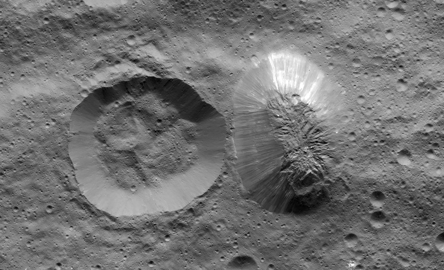
Ceres’s mysterious mountain Ahuna Mons is seen in this mosaic of images from NASA's Dawn spacecraft. Dawn took these images from its low-altitude mapping orbit, 240 miles (385 kilometers) above the surface, in December 2015. On its steepest side, this mountain is about 3 miles (5 kilometers) high. Its average overall height is 2.5 miles (4 kilometers). These figures are slightly lower than what scientists estimated from Dawn's higher orbits because researchers now have a better sense of Ceres’s topography. The diameter of the mountain is about 12 miles (20 kilometers). Researchers are exploring the processes that could have led to this feature's formation. #

The surface of Saturn and its rings, imaged by NASA’s Cassini orbiter on March 22, 2016. #

NASA's Cassini spacecraft spied details on the pockmarked surface of Saturn's moon Prometheus (86 kilometers, or 53 miles across) during a moderately close flyby on December 6, 2015. #
Cassini zoomed by Saturn's icy moon Enceladus on October 14, 2015, capturing this stunning image of the moon's north pole. Scientists expected the north polar region of Enceladus to be heavily cratered, based on low-resolution images from the Voyager mission, but high-resolution Cassini images show a landscape of stark contrasts. Thin cracks cross over the pole—the northernmost extent of a global system of such fractures. Before this Cassini flyby, scientists did not know if the fractures extended so far north on Enceladus. The view was acquired at a distance of approximately 4,000 miles (6,000 kilometers) from Enceladus. #

Saturn's moon Tethys appears to float between two sets of rings in this view from NASA's Cassini spacecraft, but it's just a trick of geometry. The rings, which are seen nearly edge-on, are the dark bands above Tethys, while their curving shadows paint the planet at the bottom of the image. Tethys, 660 miles or 1,062 kilometers across, has a surface composed mostly of water ice, much like Saturn's rings. Water ice dominates the icy surfaces in the the far reaches of our solar system, but ammonia and methane ices also can be found. Imaged on November 23, 2015. #
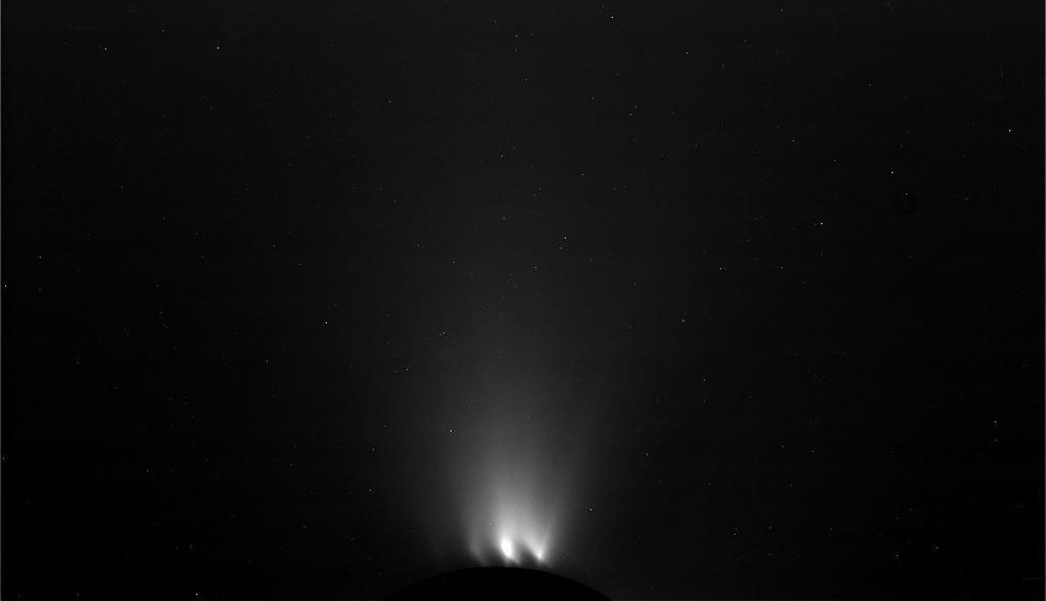
Icy plumes jet from the surface of Enceladus, seen backlit, seen by Cassini on October 28, 2015. #

NASA's Cassini spacecraft paused during its final close flyby of Enceladus to focus on the icy moon's craggy, dimly lit limb, with the planet Saturn beyond. Layers can be seen in the high hazes of Saturn's upper atmosphere, in the gradient that separates the planet from space. Imaged on December 19, 2015. #
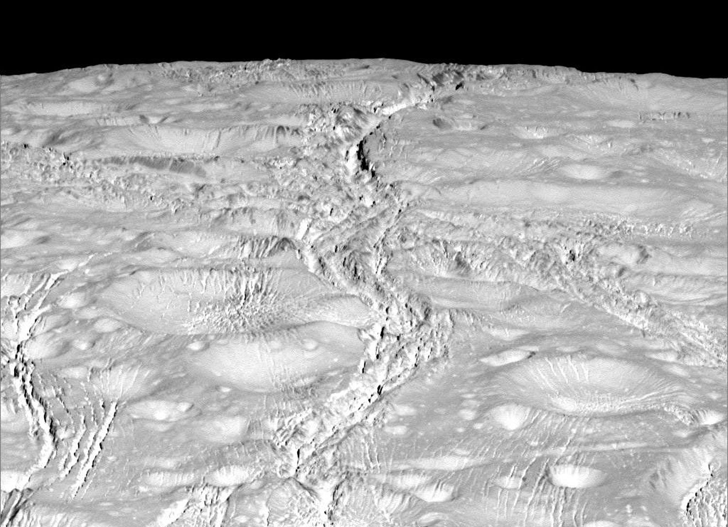
Fractured surface features on Enceladus, seen by Cassini, on October 14, 2015. #
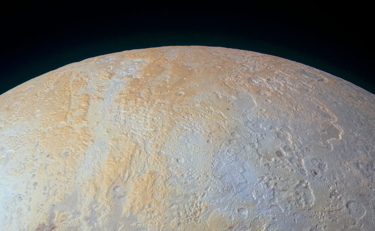
An enhanced color image of Pluto's north polar area. Long canyons run vertically across the polar area—part of the informally named Lowell Regio, named for Percival Lowell, who initiated the search that led to Pluto's discovery. The widest of the canyons is about 45 miles (75 kilometers) wide and runs close to the north pole. Roughly parallel subsidiary canyons to the east and west are approximately 6 miles (10 kilometers) wide. The degraded walls of these canyons appear to be much older than the more sharply defined canyon systems elsewhere on Pluto, perhaps because the polar canyons are older and made of weaker material. These canyons also appear to represent evidence for an ancient period of tectonics. A shallow, winding valley runs the entire length of the canyon floor. To the east of these canyons, another valley winds toward the bottom-right corner of the image. The nearby terrain, at bottom right, appears to have been blanketed by material that obscures small-scale topographic features, creating a ‘softened’ appearance for the landscape. Large, irregularly-shaped pits reach 45 miles (70 kilometers) across and 2.5 miles (4 kilometers) deep, scarring the region. These pits may indicate locations where subsurface ice has melted or sublimated from below, causing the ground to collapse. #
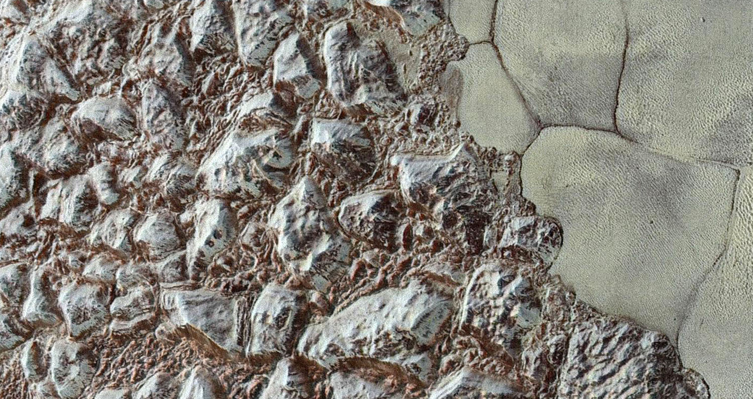
This enhanced color mosaic combines some of the sharpest views of Pluto that NASA's New Horizons spacecraft obtained during its July 14 flyby. The pictures are part of a sequence taken near New Horizons' closest approach to Pluto, with resolutions of about 250-280 feet (77-85 meters) per pixel -- revealing features smaller than half a city block on Pluto's surface. #
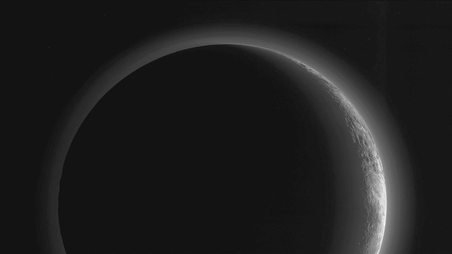
In September, the New Horizons team released a stunning but incomplete image of Pluto's crescent. Thanks to new processing work by the science team, New Horizons is releasing the entire, breathtaking image of Pluto. This image was made just 15 minutes after New Horizons’s closest approach to Pluto on July 14, 2015, as the spacecraft looked back at Pluto toward the sun. The wide-angle perspective of this view shows the deep haze layers of Pluto's atmosphere extending all the way around Pluto, revealing the silhouetted profiles of rugged plateaus on the night (left) side. The shadow of Pluto cast on its atmospheric hazes can also be seen at the uppermost part of the disk. On the sunlit side of Pluto (right), the smooth expanse of the informally named icy plain Sputnik Planum is flanked to the west (above, in this orientation) by rugged mountains up to 11,000 feet (3,500 meters) high, including the informally named Norgay Montes in the foreground and Hillary Montes on the skyline. Below (east) of Sputnik, rougher terrain is cut by apparent glaciers. The backlighting highlights more than a dozen high-altitude layers of haze in Pluto's tenuous atmosphere. The horizontal streaks in the sky beyond Pluto are stars, smeared out by the motion of the camera as it tracked Pluto. The image was taken with New Horizons' Multi-spectral Visible Imaging Camera (MVIC) from a distance of 11,000 miles (18,000 kilometers) to Pluto. #